Some years ago I acquired this screenshot from a home movie of a family towing a raft with their car across Hatteras Inlet in the 1930s. 
I thought this photo would remind our readers how fortunate we are today to have access to modern ferries.
From a newspaper account of an island delivery in 1971:
"Mrs. Dorothy Williams of Ocracoke had what could be called a very rough delivery. A 30-foot Coast Guard boat, which had picked up Mrs. Williams to take her to Hatteras to have her baby, was immobilized in heavy seas after running onto shoals. An open 17-footer tried but was unable to get along side the boat due to heavy seas and wind. Finally, an amphibious vehicle of he Coast guard rolled aboard [I think they meant "alongside"] the Coast Guard boat, bringing Dr. Dan Burroughs who delivered the baby in knee-deep water."
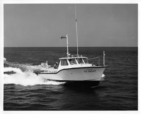
US Coast Guard 30-footer:
US Coast Guard Amphibious "Duck" Boat (all-wheel drive utility vehicle with dual rear axles):

Just a few days ago I took the following photo standing on the edge of Ride the Wind's parking area, looking out toward Silver Lake harbor. If you zoom in you can see the small Meeker cottage (with porch) on the left, between the first break in the trees and shrubs. On the other side of the larger shrub in the center you can see the former US Coast Guard Station (now the NC Center for the Advancement of Teachers).

The following photo, taken from about the same location, is a post card from sometime in the late 1950s. The Meeker cottage and the US Coast Guard station are clearly visible in the distance, as is the old store and post office (extreme right) and the Community Store (to the left of the store/post office), the tower of Berkley Manor, and Jack Willis' store (now the Working Watermen's Exhibit) further to the left.

Hello! It is Philip here, back after more than two years! It's a long story -- about lots of things, including mostly how the Blogger "Post +" button disappeared, and how I finally located the obscure link that allowed me to make new posts! Anyway, I'm back, occasionally, not every day as in the past, but at least now and then. So, for today's post:
I recently came across a December 1938 document, "Future Work Program and Plans for the Beach Erosion Control Project." This paper is about construction of erosion control dunes in Currituck, Dare, Hyde, and Cartaret counties. Most people are familiar with the row of dunes between NC12 and the ocean, although other "dykes" were created or planned for the sound side.
The author of the paper writes that, "In carrying out erosion control work on Occracoke we have encountered some of the most difficult problem[s] of the entire project." There were two areas of primary concern: on the northeastern end of Ocraocke Island from Hatteras Inlet to about 2 1/2 miles southwest; and on the southwest end of the island.
The paper goes on to report that, "The [low, sandy] flats on the west end of the island extend from the hammocks [near the present-day NPS campground]...to Ocracoke Inlet, a distance of 5 1/2 miles in length and approximately 3/4 mile in width. During very high Ocean tides the water flows over these flats in several places, and after high north winds the Sound waters flow over the flats to the Ocean. These tides generally cover the flats as a whole."
The following 1883 US Coast Guard Chart illustrates this area called "The Plains." In case you missed it, you can read more about this issue in our February 2022 Newsletter, Sand Barriers.
