Some years ago I acquired this screenshot from a home movie of a family towing a raft with their car across Hatteras Inlet in the 1930s. 
I thought this photo would remind our readers how fortunate we are today to have access to modern ferries.
From a newspaper account of an island delivery in 1971:
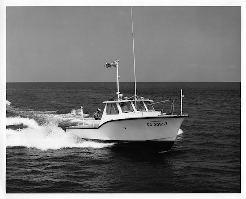
"Mrs. Dorothy Williams of Ocracoke had what could be called a very rough delivery. A 30-foot Coast Guard boat, which had picked up Mrs. Williams to take her to Hatteras to have her baby, was immobilized in heavy seas after running onto shoals. An open 17-footer tried but was unable to get along side the boat due to heavy seas and wind. Finally, an amphibious vehicle of he Coast guard rolled aboard [I think they meant "alongside"] the Coast Guard boat, bringing Dr. Dan Burroughs who delivered the baby in knee-deep water."
US Coast Guard 30-footer:
US Coast Guard Amphibious "Duck" Boat (all-wheel drive utility vehicle with dual rear axles):

Just a few days ago I took the following photo standing on the edge of Ride the Wind's parking area, looking out toward Silver Lake harbor. If you zoom in you can see the small Meeker cottage (with porch) on the left, between the first break in the trees and shrubs. On the other side of the larger shrub in the center you can see the former US Coast Guard Station (now the NC Center for the Advancement of Teachers).

The following photo, taken from about the same location, is a post card from sometime in the late 1950s. The Meeker cottage and the US Coast Guard station are clearly visible in the distance, as is the old store and post office (extreme right) and the Community Store (to the left of the store/post office), the tower of Berkley Manor, and Jack Willis' store (now the Working Watermen's Exhibit) further to the left.

Hello! It is Philip here, back after more than two years! It's a long story -- about lots of things, including mostly how the Blogger "Post +" button disappeared, and how I finally located the obscure link that allowed me to make new posts! Anyway, I'm back, occasionally, not every day as in the past, but at least now and then. So, for today's post:
I recently came across a December 1938 document, "Future Work Program and Plans for the Beach Erosion Control Project." This paper is about construction of erosion control dunes in Currituck, Dare, Hyde, and Cartaret counties. Most people are familiar with the row of dunes between NC12 and the ocean, although other "dykes" were created or planned for the sound side.
The author of the paper writes that, "In carrying out erosion control work on Occracoke we have encountered some of the most difficult problem[s] of the entire project." There were two areas of primary concern: on the northeastern end of Ocraocke Island from Hatteras Inlet to about 2 1/2 miles southwest; and on the southwest end of the island.
The paper goes on to report that, "The [low, sandy] flats on the west end of the island extend from the hammocks [near the present-day NPS campground]...to Ocracoke Inlet, a distance of 5 1/2 miles in length and approximately 3/4 mile in width. During very high Ocean tides the water flows over these flats in several places, and after high north winds the Sound waters flow over the flats to the Ocean. These tides generally cover the flats as a whole."
The following 1883 US Coast Guard Chart illustrates this area called "The Plains." In case you missed it, you can read more about this issue in our February 2022 Newsletter, Sand Barriers.

Some of our long-time readers may remember the 1977 recording of traditional Outer Banks music. It was titled "Between the Sound and the Sea," and was produced by Folkways Records. The album includes several songs by Ocracoke musicians, including my father, Lawton Howard, Elizabeth Howard, Jule Garrish, Maurice Ballance, and Edgar Howard. (You can see Edgar's grave marker, with a banjo and "You ain't heard nothing yet," directly across from Village Craftsmen on Howard Street.)

One short number ("Tom Dan'ls") performed by Edgar Howard appears to be a fragment of a longer ballad recounting a late 19th century confrontation between Ocracoke fishermen and an invasion of fishermen from Core Sound.
You can read more about the song and the 1890 Ocracoke Oyster War in our latest Ocracoke Newsletter: https://www.villagecraftsmen.com/unlocking-the-my…an-island-ballad/.
You might even want to purchase the CD directly from Smithsonian Folkways Recordings (the Newsletter includes a link).
In 1718, William Howard, quartermaster for Blackbeard the pirate, was indicted by officials in the Virginia colony. In our latest Ocracoke Newsletter you can see a copy of the original document, and read a type-written transcription describing how "the Said Wm Howard not having the Fear of God before his Eyes nor Regarding the Allegiancy due to his Majesty nor the Just Obedience he Ow'd to the Laws of the Land did some time in the Year of our Lord 1717 Join and Associate him self with one Edward Tach and other Wicked and desolute Person...."

You can see both pages of the indictment, and read the transcription here:
https://www.villagecraftsmen.com/1718-indictment-…rd-quartermaster/.
Many of our readers are familiar with the basic story of North Carolina's "Lost Colony." This was the 1587 attempt by Sir Walter Raleigh to establish an English settlement on the coast of the New World in what is now North Carolina. The colony consisted of approximately 150 men, women, and boys that settled on Roanoke Island in July, 1587, under the leadership of artist John White.
On August 18, Virginia Dare, daughter of White's daughter Eleanor and her husband, colony leader, Ananias Dare, was born, the first English child born in the New World. A few days after his granddaughter's christening, White sailed back to England to hasten and encourage efforts to resupply and reinforce the colony.
When John White returned to Roanoke Island in 1590 the colonists were gone, but White discovered the word "Croatoan" carved on a tree. Croatoan is the name of the island that, at that time, included a small section of the north end of Ocracoke Island, and the southern section of Hatteras Island, including the Buxton village area. (The present day Hatteras Inlet did not open until 1846.) Unfortunately, due to a storm, White was unable to search for the colonists, and his ships returned to England.

You can read a more complete account of the Lost Colony here: https://www.ncpedia.org/lost-colony.
For many years there has been speculation and research about what actually happened to the 1587 colony. An internet search will yield a number of links to articles and books claiming to unravel the tangled story of the "Lost Colony."
In 1960, Eastern North Carolina native, Marshall Twiford, recounted an intriguing tale about the Lost Colony that had been passed down in his family and community for many generations. Although Ocracoke (Croatoan) is mentioned in Twiford's account, he claims a different story about where the colonists settled. You can read his account in our latest Ocracoke Newsletter: https://www.villagecraftsmen.com/lost-colony-wasnt-old-tradition-says/.
In 1984, a colorful couple living on their historic 77' schooner in Silver Lake harbor created and produced a card game based on life on Ocracoke Island. Recently, a long-time visitor to Ocracoke came into possession of a rare copy of the 37-year-old game. She contacted me to learn if I knew anything about the provenance of the game.

The story of the couple, their schooner, and their adventures proved to be more interesting than the game. You can read more in our latest Ocracoke Newsletter: https://www.villagecraftsmen.com/beachcomber-the-exciting-card-game/.
Blount recently sent me this photo of the "Russell L":

The “Russell L” was a bugeye schooner, a type of sailboat developed in the Chesapeake Bay for oyster dredging. Bugeye schooners had two masts with a triangular “leg-of-mutton” mainsail, foresail and jib. As with other schooners, the mainmast was shorter than the foremast.
Ocracoke Island native, Capt. Ike (Isaac Freeman O'Neal, 1885-1968), owned and operated the "Russell L" between Ocracoke and Washington, N.C. He was also skipper of the "Relief", and the "Dryden," as well as a partner in Garrish and O'Neal's Community Store. In addition to this he did considerable commercial fishing.
The photo above shows the "Russell L" ashore on Ocracoke Island's sound side after a storm in 1922 or 1923. According to an interview with Ike in 1961, the "Russell L" could sail to Washington from Ocracoke in 5 1/2 hours at 12 nautical miles per hour.
The photo above was taken by Dr. Rhodes Tayloe Gallagher. His dog “Doc” is in the foreground.
Blount explained that one of his great aunts was married to Dr. Gallagher, a Washington dentist. Dr. Gallagher would vacation often at Ocracoke in the 1920’s, sailing on the "Russell L." Sometimes he would take his dental equipment with him (including a treadle-powered drill) and work on the Ocracokers while he was there.
Some years ago I acquired a copy of a short 1956 article from the Junior Natural History magazine about Ocracoke and the Outer Banks. The article paints quite an accurate picture of Ocracoke in the mid-twentieth century. Several photos accompanied the article. Here is one:

Today the Slushy Stand sits where the horse and the boy are running. The house with the dormers (the Murray and Elsie Tolson house) is behind the Slushy Stand and Island Ragpicker, in need of repair and barely visible because of the vegetation. The other house in the photo is the Marvin and Leevella house (Diabando rental cottage) on the corner of Lawton Lane and Howard Street.
The 1956 article ends with these words: "What will [the construction of a paved road the length of the island] do to the free-living, closely knit, picturesque sea dwellers of the island? What will be the fate of the beautiful wild horses that claim this stretch of sand and sea as their own? Only Time will tell."
Indeed!
You can read the article here: https://www.villagecraftsmen.com/ocracoke-and-the-outer-banks/
On April 5, 2018 I published this Hatteras Island story (continue reading for an update, below):
On this date in 1856 the bark Mary Varney wrecked and broke
apart off shore of Hatteras Island. Although one sailor lost his life in
the disaster, legend has it that another crew member made it to shore
in an unusual fashion, and never left.
According to one version of the story, the people of Hatteras Island had
been suffering that winter from a prolonged period of bitter cold and
lack of supplies from the mainland. Shipwrecks, as tragic as they were,
often brought much needed supplies (lumber, food, and more) to the bleak
shores of the Outer Banks. In April, 1856, one local preacher even
prayed, were a shipwreck to happen (and God forbid it would) that a
barrel of pork would wash up on the beach to help feed his hungry flock.

As it happened, when the Mary Varney broke apart the people on
shore saw a large pork barrel washing in from the stricken vessel,
tossed about by the heavy seas. It looked like the preacher's prayer had
been answered! A crowd gathered around as the barrel rolled in on a
breaker, and crashed against the sandy beach. Almost immediately the top
popped off.
To their amazement, Herbert Oden, one of the sailors on board the Mary Varney,
climbed out of the barrel. As the ship began to break apart, Oden had
emptied the barrel, and climbed in, using it as a makeshift lifeboat.
Some claim Herbert Oden was the first of his family to arrive on the
Outer Banks. He never left, and the Oden clan continues to call Hatteras
Island home!
**********************************************
Yesterday I received this email message: "I'm living in mid-coast Maine. On Sunday I visited the grave of the first family I know of that owned my house. While there I noticed an interesting inscription on the family stone which led me to do some research and eventually to you."
The writer included this report in the Burlington Free Press, April 25, 1856 (page 1):
“Barque Mary Varney, Perkins, From Norfolk for Guadeloupe, was fallen it [in?] with, 7th inst., Lat 31 42,lon. 74, [35.2N, 75.5W is probably more accurate] with her masts and houses gone, and decks swept fore and aft, the sea breaking over her; she having been capsized on the 5th, when the wife of the captain was carried overboard and lost. The captain, two officers, stewards and four colored seamen were taken off by the barque Gallego, and carried to Baltimore. They had been without food or shelter for five days when rescued.”
(https://chroniclingamerica.lo
The writer also alerted me to a photograph of the grave marker for the wife of the captain, Eliza Perkins, who was apparently the "sailor" lost when the Mary Varney wrecked. (Photo by Carolina Dutchman)

Eliza Perkins is memorialized with a cenotaph at the Pemaquid Cemetery in Bristol, Maine. She was 19 years and 8 months old. (https://www.findagrave.com/memorial/111815903/eliza-a-per
This month's Ocracoke Newsletter is a short article about the historic Williams-Tolson-Rondthaler House, known by the present owners (the Rondthalers) simply as "The Homeplace."

Although this house was damaged by flooding during Hurricane Dorian, the Rondthaler family is having it rehabilitated to historic standards. It is one of the oldest houses on the island, probably dating to before the Civil War. It is constructed, in part, from timbers salvaged from a sailing ship, and includes the island's only surviving nine-over-six window sashes.
You can read about this historic house here: https://www.villagecraftsmen.com/the-homeplace/
Friends from Washington, NC, recently sent me a digital copy of the Newsletter of the Historic Port of Washington Project. One interesting article was "The Ocracoke – Washington Freighters: The Last of an Era of Maritime Commerce" by Blount Rumley.
Rumley recounts a number of vessels, bug-eye sailboats and diesel-powered vessels, that plied Pamlico Sound until the mid-twentieth century carrying freight, animals, and passengers, as well as seafood, back and forth between Washington and Ocracoke.

Those days are gone now, but you can read about them in Blount Rumley's article which he permitted us to reprint in our latest Ocracoke Newsletter. You can read the article here:
https://www.villagecraftsmen.com/the-ocracoke-washington-freighters-by-blount-rumley/.
Carl Goerch's 1956 book, Ocracoke, includes a chapter with a list of things you wouldn't find on Ocracoke in the mid-20th century. Of course, there have been changes. We now have a few of those things Goerch mentioned. Interestingly, however, we have had over the years several other things you might find surprising...like movie theaters, a railway, a skating rink, and windmills!

Although we have not allowed comments in recent months (it was getting too time-consuming to delete all the spam comments) we are allowing comments until the end of November, 2020, if you would like to add any other items to our lists. We would love to hear from you.
One of the most remarkable rescues performed in the 44-year history of the United States Life-Saving Service occurred in February, 1905, at Cape Lookout, North Carolina.

Sick with the flu, nine surfmen at the Cape Lookout station rowed 18 miles in an open boat and endured bitter cold for twenty-eight hours to rescue six mariners from the schooner Sarah D. J. Rawson.
You can read the story in our latest Ocracoke Newsletter: https://www.villagecraftsmen.com/the-1905-rescue-of-six-mariners-from-the-schooner-sarah-d-j-rawson/.
As much as some things change, other things stay the same or change very little. Ocracoke's historic Howard Street, one of the iconic and enduring features of Ocracoke Island, has captured the attention of photographers for decades. These images below document Howard Street's appeal for residents and visitors alike.
The image below appeared on a vintage postcard from the 1950s:

This photo was on a postcard in the 1960s:

This image of the eastern end of Howard Street is from the late 1960s:

The following photo was taken in spring 2020 by Shane Claridge, a first-time visitor to the island from Canada:

There have obviously been a few changes, but the primitive beauty of Howard Street remains. Be sure to take a stroll down this lane whenever you are on the island.
We have just posted another Ocracoke Newsletter article, this time a story about how islanders coped before we had official street names. It is called "The Concrete Turtle."

We hope you find the story amusing. You can read it here: https://www.villagecraftsmen.com/the-concrete-turtle/.
Enjoy!
 |
| David Tweedie's & Amy Howard's House |
 |
| Edgar Howard, 1981, courtesy Art Mines & Elizabeth Dyer |


